Installment #4 - April 22, 1999 - Warner Springs
Well, I'm in Warner Springs - a day ahead of schedule!!! And actually I'm cold at the moment - it's overcast and almost foggy - it's cold! Yesterday, it was sunny and low 80's - that was nice! Before that it was sunny and high 90's - not so nice.
Shortly after Mount Laguna (the last report), we ran into a long dry stretch, so I picked up seven quarts of water, which added 14 pounds or so to my pack, bringing it up to around 45 pounds. I joined a group of hikers and we stopped at Pioneer Mail Trailhead picnic area for supper. They were going to stay overnight there, but I wanted to take advantage of the fact that it had cooled off somewhat to hike some more, so I went a little bit further and camped (near the top of map A8) up on top of a nob alone. It was VERY windy - it blew sand into my sleeping bag. It was windy enough that it felt like somebody was nudging me all night. [I believe that was probably just wishful thinking. -Dave] I had to tie things down so they wouldn't blow away - I had my clothes bag tied to a bush. In the morning, it took a while to get moving because you couldn't set anything down - everything had to be handled very carefully, very methodically.
After I got going, I went on down to a water stash that the guys who arranged the Saturday party had made for us. The problem was that it wasn't clear that I'd be able to find the stash, so I had to have enough water to get me through to the next known water - that's why I was carrying so much. I got to the stash and figured it was a good time to cook a meal - I was in a nice spot in the shade. So I pulled out my stove - and my stove doesn't work! The valve just won't turn on - I can't get any gas. So I had one of my cooked meals cold - made with cold water. My stove's still not working. Warner Springs is a small town (pop. 300), the next resupply spot is a little bigger, but the one after that is a good-sized town. I'm planning on going without a stove through the next stretch and then either get one or arrange to have one shipped.
Anyway, I continued on up into the heat. At one point, I missed the trail and got onto a trail that seemed right but kept getting steeper and steeper. This didn't sound like the PCT, but I kept on going. Eventually, I spotted the REAL trail over in the distance, but I couldn't get there cross-country, so I had to go back. Cost me about 45 minutes or so.
I went through an area that had been burned over for a while. Another fellow named Will caught up with me and we hiked together to Scissors Crossing . We spent the night there, where the guys who had put on the Lake Morena Party had also stashed some water for us. Then we spent yesterday hiking through the Anza-Borrego Desert. We don't really hike together - I started early in the morning, he caught up with me after a couple of hours, I caught up with him when he stopped for lunch, and we both caught up with "Meadow Ed"!
We spent last night at a place called Barrel Springs, and a fourth guy named Aaron caught up with us there. Then Will and I hiked into Warner Springs, which is where I am now.
I got blisters starting a couple of days ago, from just before we got to Scissors, so I've been limping along a little. I've been told that there is a motel about 8 miles from here - I think I'm going to stick my thumb out! We're going to stay until tomorrow - I'm ready for a little bit of luxury. I just want to lie in bed, watch TV, and rest my blisters - maybe soak them in the tub.
Basically, things are going along fairly well - I've made a couple of mistakes, like missing the trail. Another one was packing my water bag at the top of my pack without having tightened the top of it. After I shoved off, I felt water dribbling out the bottom of the pack. Most of my stuff is in plastic bags, except for my fleece jacket and my fleece cap, both of which got wet, and both of which I'm now wearing because it's cold!
[I asked Allen what the scenery's been like so far.] Well, Mount Laguna, the highest point so far, had pine trees. But otherwise, it's been primarily desert - scrub brush, cactus, Yucca plants - I'm not much on plant identification. A little bit of desert bloom, but not too much. The next mountain to the west is green and lush, but I'm in its "rain shadow" and here it is just sand.
The first couple of days, I was really buoyant - you know, this is great! - this is tremendous! - I really love this! Then I hit a low spot, and now I'm in between somewhere. Right now, I'm sitting here cold, my feet hurt, my pack is overweight - I'm ready for a break. But all in all, I'm enjoying it!
Allen
Sheesh - by the time this is over, I may actually know how to type.
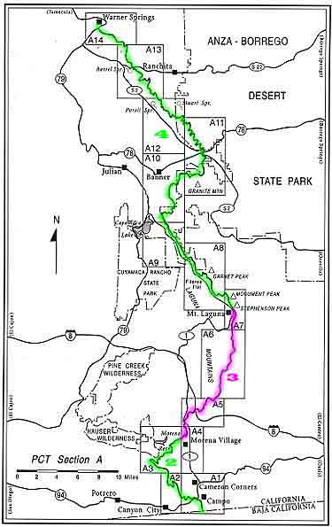
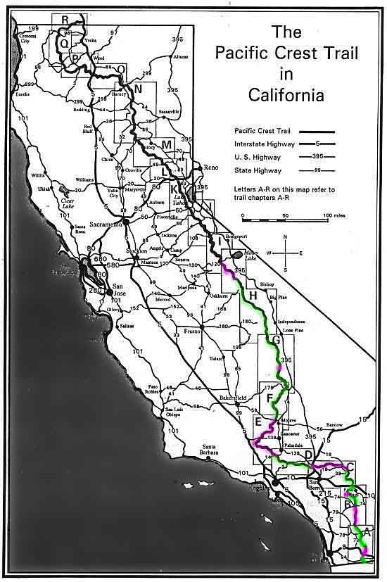
Well, our intrepid hiker is doing fine - already a day ahead of schedule and the blisters to prove it! Next update should be around Tuesday or Wednesday. Be sure to check Allen's progress on the freshly updated Chapter Map, which provides a close-up view, and on the California Map, which shows the entire state. The rectangles on the California map are lettered A through R, and these refer to the trail chapters. Allen has completed the first Chapter - a milestone! GO BIG AL!!!
Dave
Added from scans of Allen's slides on May 8:
A typical scenic view from the PCT
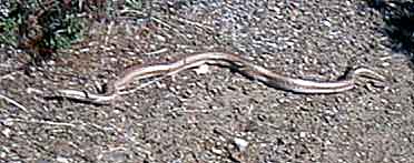
A thirty-inch traveling companion
![]()
![]()
![]()